


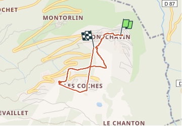
230111 Montchavin SentierNature

randodan
User

Length
3.4 km

Max alt
1445 m

Uphill gradient
240 m
Km-Effort
6.4 km

Min alt
1190 m

Downhill gradient
186 m
Boucle
No
Creation date :
2023-01-11 08:59:16.367
Updated on :
2023-01-11 14:02:11.975
5h02
Difficulty : Medium

FREE GPS app for hiking
 SityTrail
IGN / Geographical institutes
SityTrail Plus
The world is yours!
About
Trail Walking of 3.4 km to be discovered at Auvergne-Rhône-Alpes, Savoy, La Plagne-Tarentaise. This trail is proposed by randodan.
Positioning
Country:
France
Region :
Auvergne-Rhône-Alpes
Department/Province :
Savoy
Municipality :
La Plagne-Tarentaise
Location:
Bellentre
Start:(Dec)
Start:(UTM)
323525 ; 5047657 (32T) N.
Comments