


Lozanne Chazay Saint Jean des Vignes

Jean-Marc C
User
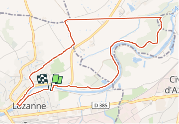

Length
6 km

Max alt
232 m

Uphill gradient
65 m
Km-Effort
6.8 km

Min alt
192 m

Downhill gradient
67 m
Boucle
Yes
Creation date :
2023-01-05 07:51:53.228
Updated on :
2023-01-12 08:11:17.077
1h08
Difficulty : Medium

FREE GPS app for hiking
 SityTrail
IGN / Geographical institutes
SityTrail Plus
The world is yours!
About
Trail Walking of 6 km to be discovered at Auvergne-Rhône-Alpes, Rhône, Lozanne. This trail is proposed by Jean-Marc C.
Positioning
Country:
France
Region :
Auvergne-Rhône-Alpes
Department/Province :
Rhône
Municipality :
Lozanne
Location:
Unknown
Start:(Dec)
Start:(UTM)
630968 ; 5079669 (31T) N.
Comments