


oulles-refuge du taillefer-grand galbert

maupassant38
User
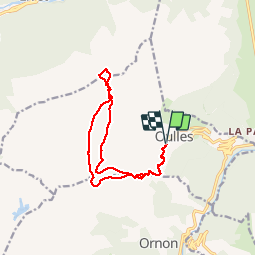

Length
14.3 km

Max alt
2546 m

Uphill gradient
1115 m
Km-Effort
29 km

Min alt
1424 m

Downhill gradient
1112 m
Boucle
Yes
Creation date :
2019-02-22 22:31:54.146
Updated on :
2019-02-22 22:31:54.22
4h21
Difficulty : Medium

FREE GPS app for hiking
 SityTrail
IGN / Geographical institutes
SityTrail Plus
The world is yours!
About
Trail Walking of 14.3 km to be discovered at Auvergne-Rhône-Alpes, Isère, Oulles. This trail is proposed by maupassant38.
Positioning
Country:
France
Region :
Auvergne-Rhône-Alpes
Department/Province :
Isère
Municipality :
Oulles
Location:
Unknown
Start:(Dec)
Start:(UTM)
734549 ; 4995313 (31T) N.
Comments