


Raquette super chatel 1er jour

jeanmarcMasson
User GUIDE
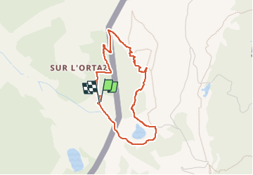

Length
3.6 km

Max alt
1871 m

Uphill gradient
245 m
Km-Effort
6.9 km

Min alt
1630 m

Downhill gradient
244 m
Boucle
Yes
Creation date :
2023-01-15 09:37:34.019
Updated on :
2023-01-15 12:04:28.902
1h30
Difficulty : Very easy

FREE GPS app for hiking
 SityTrail
IGN / Geographical institutes
SityTrail Plus
The world is yours!
About
Trail Snowshoes of 3.6 km to be discovered at Auvergne-Rhône-Alpes, Upper Savoy, Châtel. This trail is proposed by jeanmarcMasson.
Positioning
Country:
France
Region :
Auvergne-Rhône-Alpes
Department/Province :
Upper Savoy
Municipality :
Châtel
Location:
Unknown
Start:(Dec)
Start:(UTM)
334940 ; 5126005 (32T) N.
Comments