


C

raygautier
User
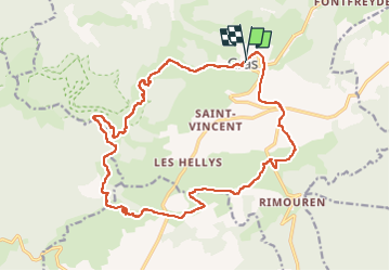

Length
22 km

Max alt
712 m

Uphill gradient
640 m
Km-Effort
30 km

Min alt
263 m

Downhill gradient
660 m
Boucle
Yes
Creation date :
2023-01-15 08:12:53.0
Updated on :
2023-01-15 15:01:20.55
4h59
Difficulty : Very difficult

FREE GPS app for hiking
 SityTrail
IGN / Geographical institutes
SityTrail Plus
The world is yours!
About
Trail Walking of 22 km to be discovered at Auvergne-Rhône-Alpes, Ardèche, Gras. This trail is proposed by raygautier.
Positioning
Country:
France
Region :
Auvergne-Rhône-Alpes
Department/Province :
Ardèche
Municipality :
Gras
Location:
Unknown
Start:(Dec)
Start:(UTM)
622567 ; 4922354 (31T) N.
Comments