


Fontaine Etoupefour 15 01 2023

cecirealain
User
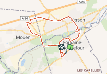

Length
8.2 km

Max alt
73 m

Uphill gradient
92 m
Km-Effort
9.5 km

Min alt
24 m

Downhill gradient
92 m
Boucle
Yes
Creation date :
2023-01-15 12:33:44.011
Updated on :
2023-01-15 15:17:28.904
2h17
Difficulty : Medium

FREE GPS app for hiking
 SityTrail
IGN / Geographical institutes
SityTrail Plus
The world is yours!
About
Trail Walking of 8.2 km to be discovered at Normandy, Calvados, Fontaine-Étoupefour. This trail is proposed by cecirealain.
Positioning
Country:
France
Region :
Normandy
Department/Province :
Calvados
Municipality :
Fontaine-Étoupefour
Location:
Unknown
Start:(Dec)
Start:(UTM)
685419 ; 5446435 (30U) N.
Comments