


Fontaine voie verte

Laurent53
User
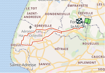

Length
12.8 km

Max alt
98 m

Uphill gradient
127 m
Km-Effort
14.5 km

Min alt
28 m

Downhill gradient
126 m
Boucle
Yes
Creation date :
2023-01-16 11:05:51.332
Updated on :
2023-01-16 11:11:04.435
3h20
Difficulty : Easy

FREE GPS app for hiking
 SityTrail
IGN / Geographical institutes
SityTrail Plus
The world is yours!
About
Trail On foot of 12.8 km to be discovered at Normandy, Seine-Maritime, Fontaine-la-Mallet. This trail is proposed by Laurent53.
Positioning
Country:
France
Region :
Normandy
Department/Province :
Seine-Maritime
Municipality :
Fontaine-la-Mallet
Location:
Unknown
Start:(Dec)
Start:(UTM)
293940 ; 5490681 (31U) N.
Comments