


raquettes 2ème jour

jeanmarcMasson
User GUIDE

Length
10.5 km

Max alt
1736 m

Uphill gradient
468 m
Km-Effort
17.1 km

Min alt
1230 m

Downhill gradient
569 m
Boucle
No
Creation date :
2023-01-16 08:57:52.646
Updated on :
2023-01-16 15:09:12.105
3h21
Difficulty : Very easy

FREE GPS app for hiking
 SityTrail
IGN / Geographical institutes
SityTrail Plus
The world is yours!
About
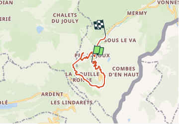
Trail Snowshoes of 10.5 km to be discovered at Auvergne-Rhône-Alpes, Upper Savoy, Châtel. This trail is proposed by jeanmarcMasson.
Photos

Positioning
Country:
France
Region :
Auvergne-Rhône-Alpes
Department/Province :
Upper Savoy
Municipality :
Châtel
Location:
Unknown
Start:(Dec)
Start:(UTM)
329432 ; 5122010 (32T) N.
Comments