


17 janvier

Tommy Eric
User
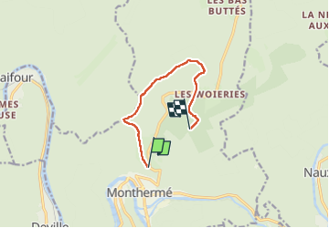

Length
6.8 km

Max alt
429 m

Uphill gradient
275 m
Km-Effort
10 km

Min alt
190 m

Downhill gradient
116 m
Boucle
No
Creation date :
2023-01-17 12:58:10.222
Updated on :
2023-01-17 15:07:02.059
1h56
Difficulty : Medium

FREE GPS app for hiking
 SityTrail
IGN / Geographical institutes
SityTrail Plus
The world is yours!
About
Trail Walking of 6.8 km to be discovered at Grand Est, Ardennes, Monthermé. This trail is proposed by Tommy Eric.
Positioning
Country:
France
Region :
Grand Est
Department/Province :
Ardennes
Municipality :
Monthermé
Location:
Unknown
Start:(Dec)
Start:(UTM)
625166 ; 5527898 (31U) N.
Comments