


rougimont tondlaine corbet druides

Titinechris
User
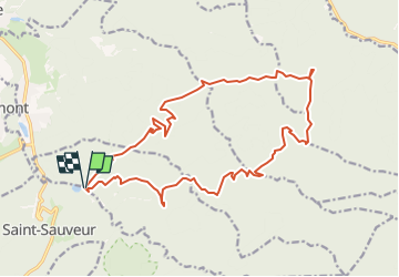

Length
19.2 km

Max alt
607 m

Uphill gradient
679 m
Km-Effort
28 km

Min alt
323 m

Downhill gradient
688 m
Boucle
Yes
Creation date :
2023-01-18 06:20:32.453
Updated on :
2023-01-18 06:21:15.467
0m
Difficulty : Easy

FREE GPS app for hiking
 SityTrail
IGN / Geographical institutes
SityTrail Plus
The world is yours!
About
Trail Trail of 19.2 km to be discovered at Grand Est, Meurthe-et-Moselle, Petitmont. This trail is proposed by Titinechris.
Positioning
Country:
France
Region :
Grand Est
Department/Province :
Meurthe-et-Moselle
Municipality :
Petitmont
Location:
Unknown
Start:(Dec)
Start:(UTM)
351229 ; 5378583 (32U) N.
Comments