


vernusse_blomard-15921268-1674037278-306

RenaudCandottiBesson
User
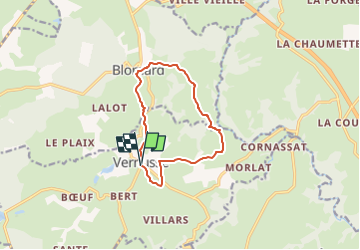

Length
10.3 km

Max alt
431 m

Uphill gradient
228 m
Km-Effort
13.4 km

Min alt
348 m

Downhill gradient
229 m
Boucle
Yes
Creation date :
2023-01-18 10:22:43.391
Updated on :
2023-01-18 10:22:43.391

FREE GPS app for hiking
 SityTrail
IGN / Geographical institutes
SityTrail Plus
The world is yours!
About
Trail of 10.3 km to be discovered at Auvergne-Rhône-Alpes, Allier, Vernusse. This trail is proposed by RenaudCandottiBesson.
Positioning
Country:
France
Region :
Auvergne-Rhône-Alpes
Department/Province :
Allier
Municipality :
Vernusse
Location:
Unknown
Start:(Dec)
Start:(UTM)
498274 ; 5123681 (31T) N.
Comments