


SityTrail - autour du Mont

noelphil
User
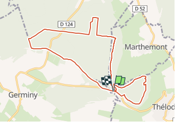

Length
10.3 km

Max alt
448 m

Uphill gradient
177 m
Km-Effort
12.7 km

Min alt
367 m

Downhill gradient
175 m
Boucle
Yes
Creation date :
2023-01-19 17:55:22.155
Updated on :
2023-01-19 17:57:48.72
2h52
Difficulty : Difficult

FREE GPS app for hiking
 SityTrail
IGN / Geographical institutes
SityTrail Plus
The world is yours!
About
Trail Walking of 10.3 km to be discovered at Grand Est, Meurthe-et-Moselle, Marthemont. This trail is proposed by noelphil.


Positioning
Country:
France
Region :
Grand Est
Department/Province :
Meurthe-et-Moselle
Municipality :
Marthemont
Location:
Unknown
Start:(Dec)
Start:(UTM)
280770 ; 5381654 (32U) N.
Comments