


Maladiere reconnaissance

janussity
User
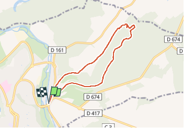

Length
6.9 km

Max alt
344 m

Uphill gradient
107 m
Km-Effort
8.4 km

Min alt
254 m

Downhill gradient
107 m
Boucle
Yes
Creation date :
2023-01-21 13:39:42.942
Updated on :
2023-01-21 15:43:13.713
1h53
Difficulty : Easy

FREE GPS app for hiking
 SityTrail
IGN / Geographical institutes
SityTrail Plus
The world is yours!
About
Trail Walking of 6.9 km to be discovered at Grand Est, Haute-Marne, Chaumont. This trail is proposed by janussity.
Description
Neige au sol soleil gel
Positioning
Country:
France
Region :
Grand Est
Department/Province :
Haute-Marne
Municipality :
Chaumont
Location:
Unknown
Start:(Dec)
Start:(UTM)
660347 ; 5331567 (31U) N.
Comments