


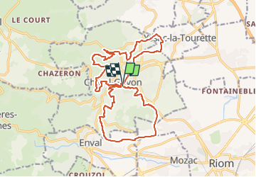
Chatel Guyon les Grosliers saint Don 21 km

jeanic63
User

Length
20 km

Max alt
590 m

Uphill gradient
500 m
Km-Effort
27 km

Min alt
376 m

Downhill gradient
498 m
Boucle
Yes
Creation date :
2023-01-21 17:14:46.294
Updated on :
2024-10-28 19:49:27.193
6h09
Difficulty : Medium

FREE GPS app for hiking
 SityTrail
IGN / Geographical institutes
SityTrail Plus
The world is yours!
About
Trail On foot of 20 km to be discovered at Auvergne-Rhône-Alpes, Puy-de-Dôme, Châtel-Guyon. This trail is proposed by jeanic63.
Description
départ Chatel Guyon parking rue du docteur Gubler
Positioning
Country:
France
Region :
Auvergne-Rhône-Alpes
Department/Province :
Puy-de-Dôme
Municipality :
Châtel-Guyon
Location:
Unknown
Start:(Dec)
Start:(UTM)
505108 ; 5085084 (31T) N.
Comments