


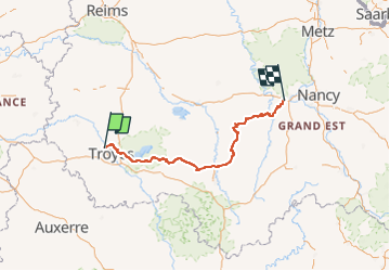
TET 16 de Troyes à Toul

DaVinci
User

Length
232 km

Max alt
409 m

Uphill gradient
3198 m
Km-Effort
274 km

Min alt
93 m

Downhill gradient
3058 m
Boucle
No
Creation date :
2023-01-22 12:09:27.582
Updated on :
2023-01-22 12:15:44.488
7h44
Difficulty : Medium

FREE GPS app for hiking
 SityTrail
IGN / Geographical institutes
SityTrail Plus
The world is yours!
About
Trail Motorbike of 232 km to be discovered at Grand Est, Aube, Barberey-Saint-Sulpice. This trail is proposed by DaVinci.
Positioning
Country:
France
Region :
Grand Est
Department/Province :
Aube
Municipality :
Barberey-Saint-Sulpice
Location:
Unknown
Start:(Dec)
Start:(UTM)
575026 ; 5353432 (31U) N.
Comments