


La Chapelle en Vexin les vignes mignot

serge.guerroult
User
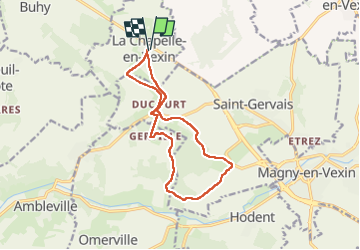

Length
12 km

Max alt
164 m

Uphill gradient
163 m
Km-Effort
14.2 km

Min alt
80 m

Downhill gradient
162 m
Boucle
Yes
Creation date :
2023-01-22 12:38:07.861
Updated on :
2023-01-22 12:38:30.568
2h39
Difficulty : Difficult

FREE GPS app for hiking
 SityTrail
IGN / Geographical institutes
SityTrail Plus
The world is yours!
About
Trail Walking of 12 km to be discovered at Ile-de-France, Val-d'Oise, La Chapelle-en-Vexin. This trail is proposed by serge.guerroult.
Positioning
Country:
France
Region :
Ile-de-France
Department/Province :
Val-d'Oise
Municipality :
La Chapelle-en-Vexin
Location:
Unknown
Start:(Dec)
Start:(UTM)
407639 ; 5448579 (31U) N.
Comments