


laille MAG chapelle 2023

ballay
User
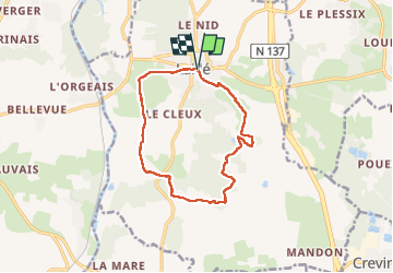

Length
11.7 km

Max alt
115 m

Uphill gradient
175 m
Km-Effort
14.1 km

Min alt
26 m

Downhill gradient
177 m
Boucle
Yes
Creation date :
2023-01-24 08:43:16.795
Updated on :
2023-01-24 15:19:56.457
2h54
Difficulty : Easy

FREE GPS app for hiking
 SityTrail
IGN / Geographical institutes
SityTrail Plus
The world is yours!
About
Trail Walking of 11.7 km to be discovered at Brittany, Ille-et-Vilaine, Laillé. This trail is proposed by ballay.
Positioning
Country:
France
Region :
Brittany
Department/Province :
Ille-et-Vilaine
Municipality :
Laillé
Location:
Unknown
Start:(Dec)
Start:(UTM)
595668 ; 5314670 (30T) N.
Comments