


millet mas soubeyran

labarone
User
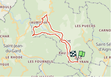

Length
16.8 km

Max alt
390 m

Uphill gradient
568 m
Km-Effort
24 km

Min alt
149 m

Downhill gradient
570 m
Boucle
Yes
Creation date :
2023-01-24 08:17:40.673
Updated on :
2023-01-24 14:15:03.02
5h20
Difficulty : Medium

FREE GPS app for hiking
 SityTrail
IGN / Geographical institutes
SityTrail Plus
The world is yours!
About
Trail Walking of 16.8 km to be discovered at Occitania, Gard, Mialet. This trail is proposed by labarone.
Description
rando tranquille
des hameaux sympa à découvrir
Positioning
Country:
France
Region :
Occitania
Department/Province :
Gard
Municipality :
Mialet
Location:
Unknown
Start:(Dec)
Start:(UTM)
576567 ; 4882891 (31T) N.
Comments