


les Grosliers Banson le puy de Thé 21 km

jeanic63
User
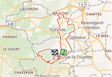

Length
20 km

Max alt
631 m

Uphill gradient
602 m
Km-Effort
28 km

Min alt
375 m

Downhill gradient
603 m
Boucle
Yes
Creation date :
2023-01-25 09:04:29.028
Updated on :
2023-01-30 17:31:32.264
6h32
Difficulty : Medium

FREE GPS app for hiking
 SityTrail
IGN / Geographical institutes
SityTrail Plus
The world is yours!
About
Trail On foot of 20 km to be discovered at Auvergne-Rhône-Alpes, Puy-de-Dôme, Châtel-Guyon. This trail is proposed by jeanic63.
Description
départ les Grosliers vers le restaurant la chopin
Positioning
Country:
France
Region :
Auvergne-Rhône-Alpes
Department/Province :
Puy-de-Dôme
Municipality :
Châtel-Guyon
Location:
Unknown
Start:(Dec)
Start:(UTM)
505760 ; 5086693 (31T) N.
Comments