


D'Evry à Viry-Châtillon

jpcccb
User
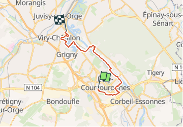

Length
17 km

Max alt
90 m

Uphill gradient
133 m
Km-Effort
18.9 km

Min alt
25 m

Downhill gradient
178 m
Boucle
No
Creation date :
2023-01-26 16:04:30.725
Updated on :
2023-04-05 16:17:19.916
4h18
Difficulty : Difficult

FREE GPS app for hiking
 SityTrail
IGN / Geographical institutes
SityTrail Plus
The world is yours!
About
Trail Walking of 17 km to be discovered at Ile-de-France, Essonne, Évry-Courcouronnes. This trail is proposed by jpcccb.
Positioning
Country:
France
Region :
Ile-de-France
Department/Province :
Essonne
Municipality :
Évry-Courcouronnes
Location:
Évry
Start:(Dec)
Start:(UTM)
457879 ; 5385995 (31U) N.
Comments