


De Parmain à Mériel, par Auvers sur Oise

jpcccb
User
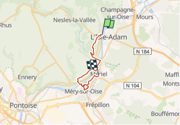

Length
13.2 km

Max alt
110 m

Uphill gradient
197 m
Km-Effort
15.8 km

Min alt
19 m

Downhill gradient
188 m
Boucle
No
Creation date :
2023-01-28 12:55:09.051
Updated on :
2023-01-28 13:03:14.9
3h35
Difficulty : Difficult

FREE GPS app for hiking
 SityTrail
IGN / Geographical institutes
SityTrail Plus
The world is yours!
About
Trail Walking of 13.2 km to be discovered at Ile-de-France, Val-d'Oise, Parmain. This trail is proposed by jpcccb.
Positioning
Country:
France
Region :
Ile-de-France
Department/Province :
Val-d'Oise
Municipality :
Parmain
Location:
Unknown
Start:(Dec)
Start:(UTM)
442323 ; 5440502 (31U) N.
Comments