


De Vaux sur Seine à Meulan

jpcccb
User
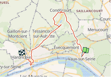

Length
12.6 km

Max alt
163 m

Uphill gradient
246 m
Km-Effort
15.9 km

Min alt
15 m

Downhill gradient
269 m
Boucle
No
Creation date :
2023-01-28 14:24:41.453
Updated on :
2023-04-27 15:20:01.936
3h37
Difficulty : Difficult

FREE GPS app for hiking
 SityTrail
IGN / Geographical institutes
SityTrail Plus
The world is yours!
About
Trail Walking of 12.6 km to be discovered at Ile-de-France, Yvelines, Vaux-sur-Seine. This trail is proposed by jpcccb.
Positioning
Country:
France
Region :
Ile-de-France
Department/Province :
Yvelines
Municipality :
Vaux-sur-Seine
Location:
Unknown
Start:(Dec)
Start:(UTM)
424188 ; 5428806 (31U) N.
Comments