


Les Terrasses de l'Aygues

MarcLEBARON
User
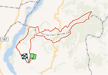

Length
11.5 km

Max alt
335 m

Uphill gradient
285 m
Km-Effort
15.3 km

Min alt
125 m

Downhill gradient
284 m
Boucle
Yes
Creation date :
2023-01-28 09:39:22.543
Updated on :
2023-02-09 14:46:19.034
3h04
Difficulty : Easy

FREE GPS app for hiking
 SityTrail
IGN / Geographical institutes
SityTrail Plus
The world is yours!
About
Trail Walking of 11.5 km to be discovered at Provence-Alpes-Côte d'Azur, Vaucluse, Cairanne. This trail is proposed by MarcLEBARON.
Photos


Positioning
Country:
France
Region :
Provence-Alpes-Côte d'Azur
Department/Province :
Vaucluse
Municipality :
Cairanne
Location:
Unknown
Start:(Dec)
Start:(UTM)
653941 ; 4900026 (31T) N.
Comments