


montagne Eymeu

philou68
User
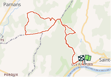

Length
13.4 km

Max alt
366 m

Uphill gradient
443 m
Km-Effort
19.3 km

Min alt
154 m

Downhill gradient
445 m
Boucle
Yes
Creation date :
2023-01-29 09:22:30.857
Updated on :
2023-01-29 12:44:35.295
3h21
Difficulty : Easy

FREE GPS app for hiking
 SityTrail
IGN / Geographical institutes
SityTrail Plus
The world is yours!
About
Trail Walking of 13.4 km to be discovered at Auvergne-Rhône-Alpes, Isère, Saint-Lattier. This trail is proposed by philou68.
Positioning
Country:
France
Region :
Auvergne-Rhône-Alpes
Department/Province :
Isère
Municipality :
Saint-Lattier
Location:
Unknown
Start:(Dec)
Start:(UTM)
672000 ; 4994798 (31T) N.
Comments