230130 Mont Saint Guibert

guy284
User
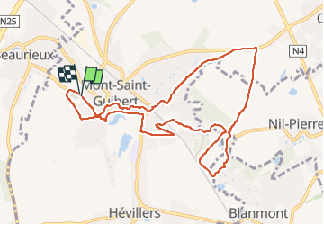

Length
9.7 km

Max alt
141 m

Uphill gradient
135 m
Km-Effort
11.5 km

Min alt
76 m

Downhill gradient
136 m
Boucle
Yes
Creation date :
2023-01-30 13:01:07.211
Updated on :
2023-02-13 21:08:17.246
2h10
Difficulty : Medium

FREE GPS app for hiking
 SityTrail
IGN / Geographical institutes
SityTrail Plus
The world is yours!
About
Trail Walking of 9.7 km to be discovered at Wallonia, Walloon Brabant, Mont-Saint-Guibert. This trail is proposed by guy284.
Positioning
Country:
Belgium
Region :
Wallonia
Department/Province :
Walloon Brabant
Municipality :
Mont-Saint-Guibert
Location:
Mont-Saint-Guibert
Start:(Dec)
Start:(UTM)
613582 ; 5610597 (31U) N.
Comments