


SityTrail - 2409689 - poligny_vauxxsurxpoligny-13km-20200524

thonyc
User GUIDE
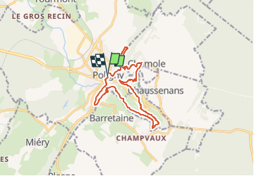

Length
13.2 km

Max alt
578 m

Uphill gradient
552 m
Km-Effort
21 km

Min alt
334 m

Downhill gradient
552 m
Boucle
Yes
Creation date :
2023-01-31 13:40:57.026
Updated on :
2023-01-31 13:48:55.081
4h39
Difficulty : Medium

FREE GPS app for hiking
 SityTrail
IGN / Geographical institutes
SityTrail Plus
The world is yours!
About
Trail Walking of 13.2 km to be discovered at Bourgogne-Franche-Comté, Jura, Poligny. This trail is proposed by thonyc.
Description
M&F
Positioning
Country:
France
Region :
Bourgogne-Franche-Comté
Department/Province :
Jura
Municipality :
Poligny
Location:
Unknown
Start:(Dec)
Start:(UTM)
706553 ; 5190335 (31T) N.
Comments