


puy de dôme 20 09 2022

jacquesduchesne
User
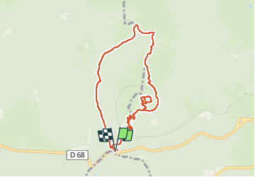

Length
9 km

Max alt
1462 m

Uphill gradient
445 m
Km-Effort
14.9 km

Min alt
1060 m

Downhill gradient
444 m
Boucle
Yes
Creation date :
2022-09-21 07:22:14.469
Updated on :
2023-01-31 14:01:09.51
3h08
Difficulty : Easy

FREE GPS app for hiking
 SityTrail
IGN / Geographical institutes
SityTrail Plus
The world is yours!
About
Trail Walking of 9 km to be discovered at Auvergne-Rhône-Alpes, Puy-de-Dôme, Orcines. This trail is proposed by jacquesduchesne.
Positioning
Country:
France
Region :
Auvergne-Rhône-Alpes
Department/Province :
Puy-de-Dôme
Municipality :
Orcines
Location:
Unknown
Start:(Dec)
Start:(UTM)
496619 ; 5067824 (31T) N.
Comments