


htthj

Jack-94
User
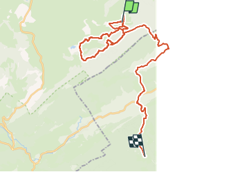

Length
35 km

Max alt
1151 m

Uphill gradient
785 m
Km-Effort
45 km

Min alt
920 m

Downhill gradient
614 m
Boucle
No
Creation date :
2023-01-30 08:17:02.863
Updated on :
2023-01-31 16:12:29.867
24h06
Difficulty : Very easy

FREE GPS app for hiking
 SityTrail
IGN / Geographical institutes
SityTrail Plus
The world is yours!
About
Trail Walking of 35 km to be discovered at Bourgogne-Franche-Comté, Jura, Cerniébaud. This trail is proposed by Jack-94.
Positioning
Country:
France
Region :
Bourgogne-Franche-Comté
Department/Province :
Jura
Municipality :
Cerniébaud
Location:
Unknown
Start:(Dec)
Start:(UTM)
279814 ; 5179749 (32T) N.
Comments