


aub

m@nu
User
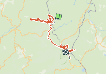

Length
52 km

Max alt
1421 m

Uphill gradient
1055 m
Km-Effort
66 km

Min alt
1192 m

Downhill gradient
985 m
Boucle
No
Creation date :
2023-01-31 10:11:38.919
Updated on :
2023-01-31 17:30:30.403
7h17
Difficulty : Very easy

FREE GPS app for hiking
 SityTrail
IGN / Geographical institutes
SityTrail Plus
The world is yours!
About
Trail Touring skiing of 52 km to be discovered at Auvergne-Rhône-Alpes, Cantal, Saint-Urcize. This trail is proposed by m@nu.
Positioning
Country:
France
Region :
Auvergne-Rhône-Alpes
Department/Province :
Cantal
Municipality :
Saint-Urcize
Location:
Unknown
Start:(Dec)
Start:(UTM)
495508 ; 4949155 (31T) N.
Comments