


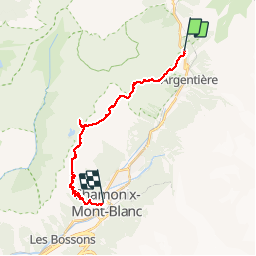
Lacs des Aiguilles rouges

arno55v
User

Length
19.9 km

Max alt
2555 m

Uphill gradient
1446 m
Km-Effort
40 km

Min alt
1037 m

Downhill gradient
1824 m
Boucle
No
Creation date :
2014-12-10 00:00:00.0
Updated on :
2014-12-10 00:00:00.0
7h50
Difficulty : Medium

FREE GPS app for hiking
 SityTrail
IGN / Geographical institutes
SityTrail Plus
The world is yours!
About
Trail Walking of 19.9 km to be discovered at Auvergne-Rhône-Alpes, Upper Savoy, Chamonix-Mont-Blanc. This trail is proposed by arno55v.
Description
Bivouac au lacs des Chéserys
Positioning
Country:
France
Region :
Auvergne-Rhône-Alpes
Department/Province :
Upper Savoy
Municipality :
Chamonix-Mont-Blanc
Location:
Unknown
Start:(Dec)
Start:(UTM)
339400 ; 5095841 (32T) N.
Comments