


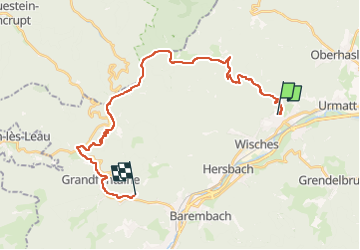
GR5 - Etape 8 - Schirmeck

jeanmarcMasson
User GUIDE

Length
26 km

Max alt
996 m

Uphill gradient
1128 m
Km-Effort
41 km

Min alt
272 m

Downhill gradient
1006 m
Boucle
No
Creation date :
2023-02-02 10:54:40.313
Updated on :
2023-02-02 10:59:15.546
9h17
Difficulty : Very difficult

FREE GPS app for hiking
 SityTrail
IGN / Geographical institutes
SityTrail Plus
The world is yours!
About
Trail Walking of 26 km to be discovered at Grand Est, Bas-Rhin, Lutzelhouse. This trail is proposed by jeanmarcMasson.
Positioning
Country:
France
Region :
Grand Est
Department/Province :
Bas-Rhin
Municipality :
Lutzelhouse
Location:
Unknown
Start:(Dec)
Start:(UTM)
373246 ; 5375846 (32U) N.
Comments