


Cézallier

m@nu
User

Length
40 km

Max alt
1485 m

Uphill gradient
913 m
Km-Effort
52 km

Min alt
1285 m

Downhill gradient
914 m
Boucle
Yes
Creation date :
2023-02-03 08:47:18.769
Updated on :
2023-02-03 16:52:20.203
7h35
Difficulty : Very easy

FREE GPS app for hiking
 SityTrail
IGN / Geographical institutes
SityTrail Plus
The world is yours!
About
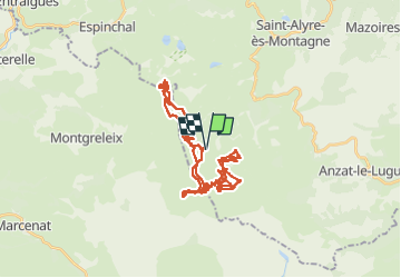
Trail Touring skiing of 40 km to be discovered at Auvergne-Rhône-Alpes, Puy-de-Dôme, Saint-Alyre-ès-Montagne. This trail is proposed by m@nu.
Positioning
Country:
France
Region :
Auvergne-Rhône-Alpes
Department/Province :
Puy-de-Dôme
Municipality :
Saint-Alyre-ès-Montagne
Location:
Unknown
Start:(Dec)
Start:(UTM)
495455 ; 5020692 (31T) N.
Comments