


Vauvert 31 01 23

Dupuybadonniere
User
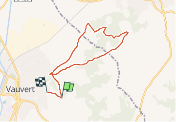

Length
8.5 km

Max alt
105 m

Uphill gradient
121 m
Km-Effort
10.1 km

Min alt
37 m

Downhill gradient
105 m
Boucle
No
Creation date :
2023-01-31 13:05:37.972
Updated on :
2023-02-05 15:38:23.944
1h51
Difficulty : Medium

FREE GPS app for hiking
 SityTrail
IGN / Geographical institutes
SityTrail Plus
The world is yours!
About
Trail Walking of 8.5 km to be discovered at Occitania, Gard, Vauvert. This trail is proposed by Dupuybadonniere.
Positioning
Country:
France
Region :
Occitania
Department/Province :
Gard
Municipality :
Vauvert
Location:
Unknown
Start:(Dec)
Start:(UTM)
603985 ; 4838268 (31T) N.
Comments