


A

raygautier
User
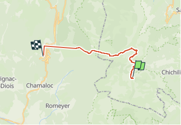

Length
17.6 km

Max alt
1808 m

Uphill gradient
589 m
Km-Effort
27 km

Min alt
1097 m

Downhill gradient
1096 m
Boucle
No
Creation date :
2023-02-05 07:09:58.0
Updated on :
2023-02-06 09:10:14.166
4h05
Difficulty : Medium

FREE GPS app for hiking
 SityTrail
IGN / Geographical institutes
SityTrail Plus
The world is yours!
About
Trail Road bike of 17.6 km to be discovered at Auvergne-Rhône-Alpes, Isère, Chichilianne. This trail is proposed by raygautier.
Photos

Positioning
Country:
France
Region :
Auvergne-Rhône-Alpes
Department/Province :
Isère
Municipality :
Chichilianne
Location:
Unknown
Start:(Dec)
Start:(UTM)
698630 ; 4964578 (31T) N.
Comments