


Fontaine le Dun

juanluco76
User
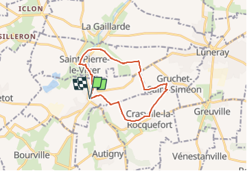

Length
10.5 km

Max alt
96 m

Uphill gradient
109 m
Km-Effort
11.9 km

Min alt
34 m

Downhill gradient
106 m
Boucle
Yes
Creation date :
2023-02-06 12:54:30.506
Updated on :
2023-02-06 12:55:04.123
2h42
Difficulty : Medium

FREE GPS app for hiking
 SityTrail
IGN / Geographical institutes
SityTrail Plus
The world is yours!
About
Trail Walking of 10.5 km to be discovered at Normandy, Seine-Maritime, Fontaine-le-Dun. This trail is proposed by juanluco76.
Positioning
Country:
France
Region :
Normandy
Department/Province :
Seine-Maritime
Municipality :
Fontaine-le-Dun
Location:
Unknown
Start:(Dec)
Start:(UTM)
345340 ; 5520068 (31U) N.
Comments