


curienne fontaine froide

papou73
User

Length
7.8 km

Max alt
713 m

Uphill gradient
279 m
Km-Effort
11.6 km

Min alt
504 m

Downhill gradient
279 m
Boucle
Yes
Creation date :
2023-02-07 14:40:10.192
Updated on :
2023-02-07 14:43:48.88
2h37
Difficulty : Medium

FREE GPS app for hiking
 SityTrail
IGN / Geographical institutes
SityTrail Plus
The world is yours!
About
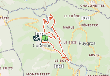
Trail Walking of 7.8 km to be discovered at Auvergne-Rhône-Alpes, Savoy, Curienne. This trail is proposed by papou73.
Description
circuit Curienne, Fontaine froide, trou de l'enfer, Ternèze, Boyat, Curienne.
Positioning
Country:
France
Region :
Auvergne-Rhône-Alpes
Department/Province :
Savoy
Municipality :
Curienne
Location:
Unknown
Start:(Dec)
Start:(UTM)
266547 ; 5050248 (32T) N.
Comments