


Les coteaux de Châteauguay

Gegetop
User
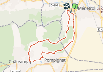

Length
8.4 km

Max alt
511 m

Uphill gradient
215 m
Km-Effort
11.3 km

Min alt
340 m

Downhill gradient
213 m
Boucle
Yes
Creation date :
2023-02-08 12:58:17.309
Updated on :
2023-02-08 15:03:54.679
2h30
Difficulty : Medium
2h00
Difficulty : Medium

FREE GPS app for hiking
 SityTrail
IGN / Geographical institutes
SityTrail Plus
The world is yours!
About
Trail Walking of 8.4 km to be discovered at Auvergne-Rhône-Alpes, Puy-de-Dôme, Riom. This trail is proposed by Gegetop.
Description
Balade sur le circuit "les pas des vignerons" et oeuno-touristique de Châteauguay.
Positioning
Country:
France
Region :
Auvergne-Rhône-Alpes
Department/Province :
Puy-de-Dôme
Municipality :
Riom
Location:
Unknown
Start:(Dec)
Start:(UTM)
508981 ; 5079678 (31T) N.
Comments