


rando Milly 70 ans J-Luc

jeanmarcMasson
User GUIDE
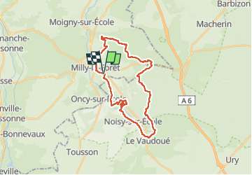

Length
27 km

Max alt
130 m

Uphill gradient
258 m
Km-Effort
31 km

Min alt
63 m

Downhill gradient
258 m
Boucle
Yes
Creation date :
2023-02-08 08:43:44.174
Updated on :
2023-02-08 16:32:35.545
5h51
Difficulty : Very difficult

FREE GPS app for hiking
 SityTrail
IGN / Geographical institutes
SityTrail Plus
The world is yours!
About
Trail Walking of 27 km to be discovered at Ile-de-France, Essonne, Milly-la-Forêt. This trail is proposed by jeanmarcMasson.
Positioning
Country:
France
Region :
Ile-de-France
Department/Province :
Essonne
Municipality :
Milly-la-Forêt
Location:
Unknown
Start:(Dec)
Start:(UTM)
461448 ; 5360772 (31U) N.
Comments