


fer à cheval

dewaeph
User
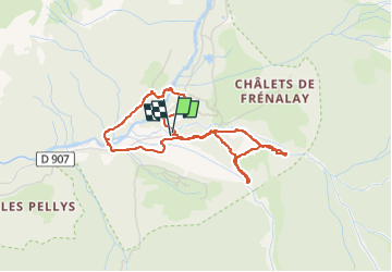

Length
3.9 km

Max alt
1014 m

Uphill gradient
127 m
Km-Effort
5.6 km

Min alt
918 m

Downhill gradient
127 m
Boucle
Yes
Creation date :
2023-02-09 08:54:41.438
Updated on :
2023-02-09 10:44:04.447
1h49
Difficulty : Easy

FREE GPS app for hiking
 SityTrail
IGN / Geographical institutes
SityTrail Plus
The world is yours!
About
Trail Walking of 3.9 km to be discovered at Auvergne-Rhône-Alpes, Upper Savoy, Sixt-Fer-à-Cheval. This trail is proposed by dewaeph.
Positioning
Country:
France
Region :
Auvergne-Rhône-Alpes
Department/Province :
Upper Savoy
Municipality :
Sixt-Fer-à-Cheval
Location:
Unknown
Start:(Dec)
Start:(UTM)
332751 ; 5104811 (32T) N.
Comments