


challenge rando Ascegee

Tommy Eric
User
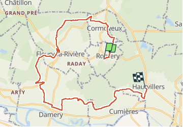

Length
19.4 km

Max alt
274 m

Uphill gradient
480 m
Km-Effort
26 km

Min alt
77 m

Downhill gradient
445 m
Boucle
No
Creation date :
2023-02-09 09:21:46.034
Updated on :
2023-02-09 14:23:58.008
4h03
Difficulty : Very difficult

FREE GPS app for hiking
 SityTrail
IGN / Geographical institutes
SityTrail Plus
The world is yours!
About
Trail Walking of 19.4 km to be discovered at Grand Est, Marne, Romery. This trail is proposed by Tommy Eric.
Positioning
Country:
France
Region :
Grand Est
Department/Province :
Marne
Municipality :
Romery
Location:
Unknown
Start:(Dec)
Start:(UTM)
566657 ; 5438451 (31U) N.
Comments