


rando ANC octobre 23

Tommy Eric
User
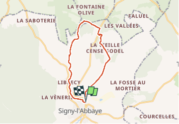

Length
10.8 km

Max alt
277 m

Uphill gradient
207 m
Km-Effort
13.5 km

Min alt
141 m

Downhill gradient
205 m
Boucle
Yes
Creation date :
2023-02-14 13:08:44.842
Updated on :
2023-02-14 16:35:13.413
2h35
Difficulty : Difficult

FREE GPS app for hiking
 SityTrail
IGN / Geographical institutes
SityTrail Plus
The world is yours!
About
Trail Walking of 10.8 km to be discovered at Grand Est, Ardennes, Signy-l'Abbaye. This trail is proposed by Tommy Eric.
Positioning
Country:
France
Region :
Grand Est
Department/Province :
Ardennes
Municipality :
Signy-l'Abbaye
Location:
Unknown
Start:(Dec)
Start:(UTM)
602633 ; 5506467 (31U) N.
Comments
phénomène géologique du signacien.