


Rosières les Fontaines

Linerou
User
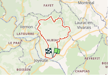

Length
14 km

Max alt
383 m

Uphill gradient
327 m
Km-Effort
18.4 km

Min alt
153 m

Downhill gradient
329 m
Boucle
Yes
Creation date :
2023-02-16 08:40:51.006
Updated on :
2023-02-16 14:12:44.438
3h41
Difficulty : Medium

FREE GPS app for hiking
 SityTrail
IGN / Geographical institutes
SityTrail Plus
The world is yours!
About
Trail Walking of 14 km to be discovered at Auvergne-Rhône-Alpes, Ardèche, Rosières. This trail is proposed by Linerou.
Positioning
Country:
France
Region :
Auvergne-Rhône-Alpes
Department/Province :
Ardèche
Municipality :
Rosières
Location:
Unknown
Start:(Dec)
Start:(UTM)
599810 ; 4926218 (31T) N.
Comments