


Carqueiranne rassemblement

giovannoni
User
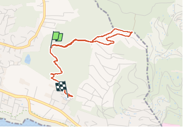

Length
4.2 km

Max alt
294 m

Uphill gradient
138 m
Km-Effort
6.4 km

Min alt
50 m

Downhill gradient
239 m
Boucle
No
Creation date :
2023-02-16 14:59:51.0
Updated on :
2023-02-16 17:22:25.539
1h45
Difficulty : Medium

FREE GPS app for hiking
 SityTrail
IGN / Geographical institutes
SityTrail Plus
The world is yours!
About
Trail Walking of 4.2 km to be discovered at Provence-Alpes-Côte d'Azur, Var, Carqueiranne. This trail is proposed by giovannoni.
Positioning
Country:
France
Region :
Provence-Alpes-Côte d'Azur
Department/Province :
Var
Municipality :
Carqueiranne
Location:
Unknown
Start:(Dec)
Start:(UTM)
263195 ; 4775596 (32T) N.
Comments