


chalet de l'as - alpage de la peyrouse

maupassant38
User
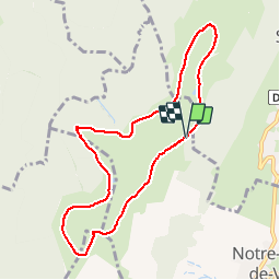

Length
8.8 km

Max alt
1707 m

Uphill gradient
434 m
Km-Effort
14.6 km

Min alt
1458 m

Downhill gradient
427 m
Boucle
Yes
Creation date :
2019-02-22 22:31:51.423
Updated on :
2019-02-22 22:31:51.438
2h28
Difficulty : Medium

FREE GPS app for hiking
 SityTrail
IGN / Geographical institutes
SityTrail Plus
The world is yours!
About
Trail Walking of 8.8 km to be discovered at Auvergne-Rhône-Alpes, Isère, Notre-Dame-de-Vaulx. This trail is proposed by maupassant38.
Positioning
Country:
France
Region :
Auvergne-Rhône-Alpes
Department/Province :
Isère
Municipality :
Notre-Dame-de-Vaulx
Location:
Unknown
Start:(Dec)
Start:(UTM)
715795 ; 4986855 (31T) N.
Comments