


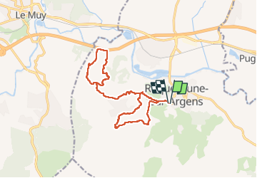
Cimetière Roquebrune / Argens - La Maurette - 3 Croix - Grotte de l'Ermite

LtZIP
User

Length
17.4 km

Max alt
340 m

Uphill gradient
700 m
Km-Effort
27 km

Min alt
15 m

Downhill gradient
699 m
Boucle
Yes
Creation date :
2023-02-19 07:56:55.831
Updated on :
2023-02-20 10:10:23.822
4h52
Difficulty : Medium

FREE GPS app for hiking
 SityTrail
IGN / Geographical institutes
SityTrail Plus
The world is yours!
About
Trail Walking of 17.4 km to be discovered at Provence-Alpes-Côte d'Azur, Var, Roquebrune-sur-Argens. This trail is proposed by LtZIP.
Description
IBP
Rouge 83
Passages délicats pour l'accès aux 3 croix et la descente.
Photos


Positioning
Country:
France
Region :
Provence-Alpes-Côte d'Azur
Department/Province :
Var
Municipality :
Roquebrune-sur-Argens
Location:
Unknown
Start:(Dec)
Start:(UTM)
308469 ; 4812401 (32T) N.
Comments