


ctm

nouga
User
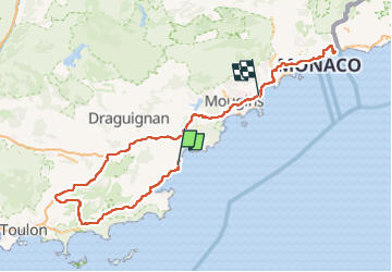

Length
317 km

Max alt
567 m

Uphill gradient
6682 m
Km-Effort
407 km

Min alt
0 m

Downhill gradient
6683 m
Boucle
No
Creation date :
2023-02-14 10:37:16.192
Updated on :
2023-02-19 21:23:00.957
10h51
Difficulty : Very difficult

FREE GPS app for hiking
 SityTrail
IGN / Geographical institutes
SityTrail Plus
The world is yours!
About
Trail Mountain bike of 317 km to be discovered at Provence-Alpes-Côte d'Azur, Var, Roquebrune-sur-Argens. This trail is proposed by nouga.
Positioning
Country:
France
Region :
Provence-Alpes-Côte d'Azur
Department/Province :
Var
Municipality :
Roquebrune-sur-Argens
Location:
Unknown
Start:(Dec)
Start:(UTM)
314607 ; 4803966 (32T) N.
Comments