


Antrain chauvigné par GR BIS 17KM

coglais
User
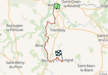

Length
16.7 km

Max alt
101 m

Uphill gradient
272 m
Km-Effort
20 km

Min alt
21 m

Downhill gradient
241 m
Boucle
No
Creation date :
2023-02-22 09:07:40.859
Updated on :
2023-02-22 09:08:37.72
3h00
Difficulty : Medium

FREE GPS app for hiking
 SityTrail
IGN / Geographical institutes
SityTrail Plus
The world is yours!
About
Trail Nordic walking of 16.7 km to be discovered at Brittany, Ille-et-Vilaine, Val-Couesnon. This trail is proposed by coglais.
Positioning
Country:
France
Region :
Brittany
Department/Province :
Ille-et-Vilaine
Municipality :
Val-Couesnon
Location:
Antrain
Start:(Dec)
Start:(UTM)
611912 ; 5367321 (30U) N.
Comments