


AUTOUR DU PLATEAU DE VELIZY

NUITEVEN
User
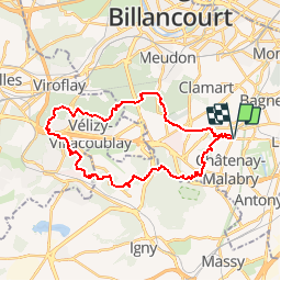

Length
29 km

Max alt
187 m

Uphill gradient
586 m
Km-Effort
37 km

Min alt
96 m

Downhill gradient
589 m
Boucle
Yes
Creation date :
2017-12-03 00:00:00.0
Updated on :
2017-12-03 00:00:00.0
7h40
Difficulty : Easy

FREE GPS app for hiking
 SityTrail
IGN / Geographical institutes
SityTrail Plus
The world is yours!
About
Trail Walking of 29 km to be discovered at Ile-de-France, Hauts-de-Seine, Châtenay-Malabry. This trail is proposed by NUITEVEN.
Positioning
Country:
France
Region :
Ile-de-France
Department/Province :
Hauts-de-Seine
Municipality :
Châtenay-Malabry
Location:
Unknown
Start:(Dec)
Start:(UTM)
447107 ; 5403149 (31U) N.
Comments