


Saint Romain de Popey - Mont Popey

Jean-Marc C
User
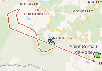

Length
4.5 km

Max alt
523 m

Uphill gradient
238 m
Km-Effort
7.5 km

Min alt
404 m

Downhill gradient
190 m
Boucle
No
Creation date :
2023-02-23 08:10:50.831
Updated on :
2023-02-23 10:59:09.289
39m
Difficulty : Medium

FREE GPS app for hiking
 SityTrail
IGN / Geographical institutes
SityTrail Plus
The world is yours!
About
Trail Walking of 4.5 km to be discovered at Auvergne-Rhône-Alpes, Rhône, Saint-Romain-de-Popey. This trail is proposed by Jean-Marc C.
Positioning
Country:
France
Region :
Auvergne-Rhône-Alpes
Department/Province :
Rhône
Municipality :
Saint-Romain-de-Popey
Location:
Unknown
Start:(Dec)
Start:(UTM)
619100 ; 5077911 (31T) N.
Comments