


Bonnefontaine-Chauvigné 14,7km JY

COGLAIS3
User
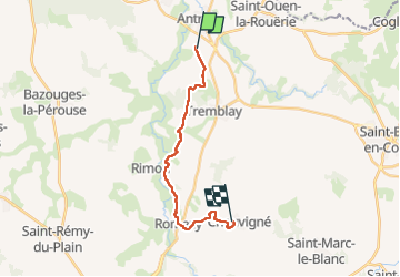

Length
14.7 km

Max alt
105 m

Uphill gradient
215 m
Km-Effort
17.5 km

Min alt
21 m

Downhill gradient
184 m
Boucle
No
Creation date :
2023-02-23 07:51:40.246
Updated on :
2023-02-24 20:15:14.966
3h34
Difficulty : Easy

FREE GPS app for hiking
 SityTrail
IGN / Geographical institutes
SityTrail Plus
The world is yours!
About
Trail Nordic walking of 14.7 km to be discovered at Brittany, Ille-et-Vilaine, Val-Couesnon. This trail is proposed by COGLAIS3.
Positioning
Country:
France
Region :
Brittany
Department/Province :
Ille-et-Vilaine
Municipality :
Val-Couesnon
Location:
Antrain
Start:(Dec)
Start:(UTM)
611936 ; 5367330 (30U) N.
Comments